Reporting Arc Hydro Issues
Last updated: 2023
Download the PDF here
Arc Hydro is intended to provide practical GIS framework for development of integrated analytical systems for water resources professionals and consists of a data model, tools, workflows, and community sharing experiences and ideas. Arc Hydro has many tools and workflows supporting many areas of water resources.
An overview of Arc Hydro and a discussion of its implementation have been presented and discussed in the 4-part webinar series: Arc Hydro in Action (2021). The first webinar, Arc Hydro in ArcGIS Pro, presents general Arc Hydro concepts and is a good starting point to understand what Arc Hydro is and is not.
Arc Hydro has been in continuous development since its initial release in 2002. There are many supporting resources. Links to all references can be found in the document: Learning about Arc Hydro: Resources and Documentation
This document is not intended to teach Arc Hydro - it provides information on how to report issues encountered in using Arc Hydro tools, assuming that you have basic Arc Hydro skills in place.
Mandatory Reading
Most of the reported issues in using Arc Hydro over the years can be attributed to the following five categories:
Installation issues. This primarily includes installation of wrong version of tools for the underlying ArcGIS desktop platform. This includes specific versions of both ArcMap and Pro. Arc Hydro tools are specific to the version of the underlying desktop. For example, Arc Hydro tools for ArcGIS Pro 2.8 will not necessarily work for Pro 2.9. For proper installation of the tools, follow instructions in Downloading and Installing Arc Hydro Tools.
Data organization. Arc Hydro tools are fundamentally analytical tools and require certain rigor in preparation and use. Read Arc Hydro: Project Development Best Practices
- this technical paper captures what works well when implementing Arc Hydro projects both in ArcMap and ArcGIS Pro. This is required reading - follow the recommendations closely, especially as you are getting into Arc Hydro. Once you are comfortable you can begin to move past the recommendations (but be ready for surprises). Pay attention to:
Projections / spatial reference.
Folder and geodatabase organization.
Folder, geodatabase, feature class, and attribute naming conventions.
Data size (and quirks). Attempting to use tools on large data that might not be supported by the hardware or the tools.
Whenever using new workflows and tools and are running into issue, try to run them first on a smaller spatial extent.
If a smaller dataset is not working, make sure that the data are "valid". Vector data should always be feature classes. Raster data should (in general) be in tif or grid formats, and ideally applied consistently.
Workflows. Often, Arc Hydro tools build on specific sequence of tool execution (workflow). Using tools in incorrect order (or skipping steps) might cause problems for tools that are used later in the workflow.
Tool deficiencies / problems. This in general falls into two categories:
Deficiencies. Tool works, produces correct results, but the results do not meet user needs. The tool would have to be modified to produce "better" results. This is a tool enhancement.
Bugs. Tool does not work (fails in execution) or produces wrong results.
This document discusses reporting of tool problems defined in 5.b. Most other issues can be resolved by carefully following guidelines for tool installation and best use practices referenced earlier in the document. In particular, the best practice document in section 6 - "Debugging and workarounds", goes over steps to try to resolve general issues with Arc Hydro tools use. If these attempts fail, the rest of this document will present how to report the problem to the Arc Hydro team.
Tool Problem Reporting
If attempts to resolve tool problems as described in the best practice document, section 6 - "Debugging and workarounds" fail, provide the following information about the problem:
ArcGIS desktop version (e.g., ArcGIS Pro 2.9.2).
Arc Hydro tools version (e.g., 2.9.27).
Tool name and screen shot of the tool with populated inputs and outputs (e.g., "Construct 3D Line")
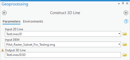
Screenshot of tool inputs in the active map view.
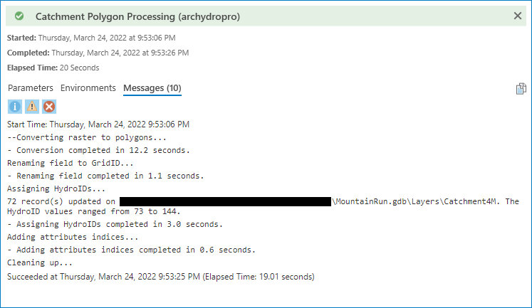
Screenshot of the error that the tool produces (if any is generated). If tool has completed but has not generated a correct result, provide the screenshot of the completed tool.
Size of the inputs - for vectors, number of features, for rasters, number of rows and columns.
If part of specific workflow, steps that have been performed prior to the tool use.
Direct contact information.
Any other additional pertinent information that you might think could help in troubleshooting.
Email the information (best as a word doc) to: archydro@esri.com
In case we can reproduce the problem with our data, we will fix the problem if it is a "bug" and release the fix in the next Arc Hydro tool version. If it is an enhancement to existing tool capability, we will consider implementing the enhancement for some future release. That will greatly depend on whether other users have expressed interest in such an enhancement.
If we are not able to reproduce the problem with our data, we might contact you and request your data that are generating the problem and try to reproduce the problem with your data in our IT environment.
Thank you for your interest in Arc Hydro and contributing to the effort.